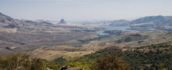
Beyond the Seven Mountains, with the seven dwarves there dwells a beauty or so the tale goes. But no beauty like you might think now, deep in the Caucasian mountains, surrounded by 4000 m peaks lies the hidden valley of Tusheti with a landscape worthy of a fairy tale.
To get there is not for the faint fo heart though. The only rideable road crosses the Abano mountain pass. With 2850 m it’s not the highest one of this voyage but it surely was the most spectacular and nerve-racking. After my departure from Tbilisi and a short ride, I came to the Caucasian mountain range, where I followed the road along a river valley. Soon the pavement ended, the mountains drew closer and the road became steeper and rougher. Not long after I found myself in between a cliff to my left, a gorge to my right with only a narrow 2 m wide stretch of road cambering towards the latter. And this was only the beginning, to reach the top, I had to cross creeks, climb inclines of loose gravel, steps in the bedrock and navigate mad switchbacks.
After the subsequent descend into the valley more than one thousand meters below the passheight, one feels like near the end of the world. Tusheti is almost completely cut off from the rest of Georgia, since the road is only passable during a few short months in the summer. The valley itself is mainly inhabited by mountain farmers and the villages here seem to be unchanged for centuries. Houses made from wood and rough stones, dogs guarding flocks of horses and sheep on the meadows; the idyll is only disturbed by russian trucks, japanese jeeps and western tourists, who are probably the main source of income for the locals nowadays.


After overcoming the pass for a second time, this time after some heavy rains (that made the rocks slippery and the switchbacks extra tricky to navigate), landslides (that deposited gravel, rocks and branches on the road) and in thick fog (that hid the fifty meter drops right next to the road; one thing less to worry about), the Georgian Military Highway was a cakewalk. This road is the only connection between Russia and Georgia, continuously paved and comparably busy.
Shortly before the russian border at the feet of Mount Kazbek, there is the town of Stepantsminda. The local tourist attraction, Gergeti Trinity Church, is just another one of those armenian/georgian lookalike monasteries. I preferred the Snotskhali, a side valley with an amazing campsite in the village of Juta at its end. Here I spend a day of hiking and climbed the pass to, but not descending into the Arghun valley to the east.


To visit this valley was the plan for the next day. The distance from Juta to Roshka in the other valley is either 25 km afoot over the pass or 160 km for the traveller burdened with two wheels, who has to backtrack the Military Road out of the mountains to find the entrance to the Arghun valley and follow its whole length northwards. So I arrived at the same time at the guesthouse in Roshka as Debbie, a british hiker who departed at a similar time in Juta but took the path over the mountains. The guesthouse is run by a very hospital and artistically gifted family who also tries to preserve the tradition and cultural heritage of the local population. They maintain a small exhibit of different artifacts like tools, weapons, household items, clothes, hunting trophies, written documents and pictures from the inhabitants of Khevsureti. I couldn’t believe it until I saw the pictures here, but until the 1930 people in this valley still wore chain mail armour and used sword, shields and muskets.
Prepared with this knowledge I made my way to the end of the valley, to see the fortified villages of Shatili and Mutso. Both are only a few hundred meters off the border to Russia and served as border fortifications for the medieval Kingdom of Georgia.


Route (Fullscreen):
Thank you for writhing this journal of your travel to Eastern Europe. I enjoyed it very much. The pictures are of excellent quality. My favorite is the tent under the Milky Way. This Summer, I plan to travel the Trans-Labrador Highway north of Baie Comeau, QC Canada. My motorcycle is a 2016 BMW F700 GS.